IRNSS: Desi GPS to liberate India from dependence on US, Russia
The scientists who were till then glued to their monitors burst into cheers. India’s mini GPS, a regional positioning system, was ready to be rolled out.
Updated:

By Vanita Srivastava
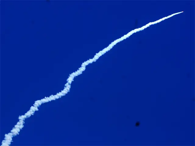
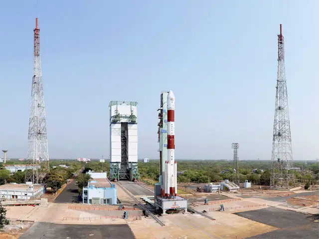
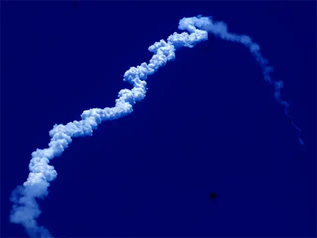
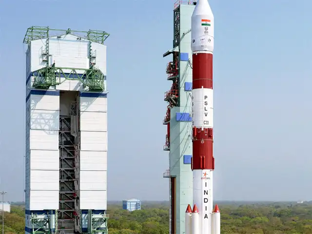
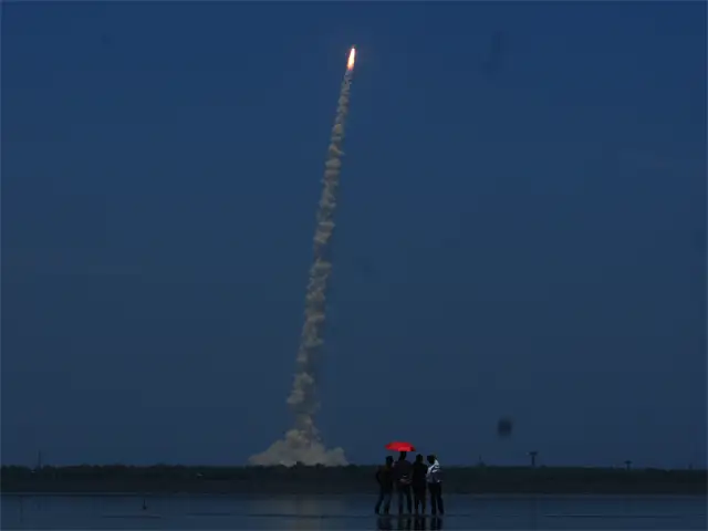
April 28. At 12.50 pm sharp, a 44.4-metre-tall PSLV rocket, weighing 320 tonnes, blasted into the clear afternoon skies from Sriharikota in Andhra Pradesh with a blazing orangered tail trailing behind. After zooming through the sky for nearly 20 minutes, the satellite IRNSS-1G was ejected from the rocket and injected into an elliptical orbit. It swiftly opened its solar panels.
Back home, the mission control room of Indian Space Research Organisation(ISRO) resonated with thunderous applause. The scientists who were till then glued to their monitors burst into cheers. India’s mini GPS, a regional positioning system, was ready to be rolled out.
Prime minister Narendra Modi who was watching the launch live from his office in Delhi congratulated the scientists. “With this successful launch, we will determine our own paths powered by our technology. This is an example of made in India and made for Indians,” he said. The navigational structure was given a new name — NavIC (Navigation Indian Constellation) — by the prime minister. “125 crore Indians have got a new Navic,” he tweeted.
Desi GPS
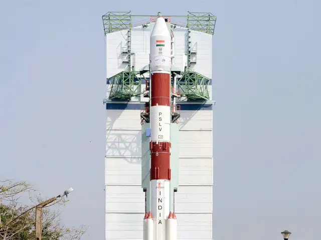
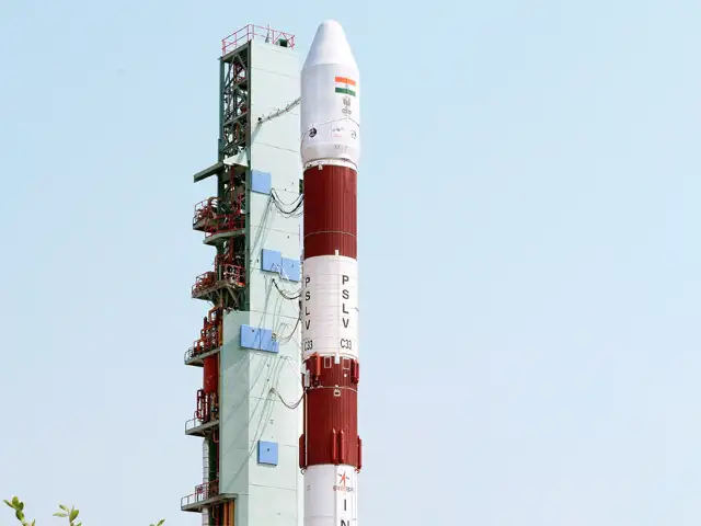
The seven-satellite constellation, IRNSS (Indian Regional Navigation Satellite System), is designed to provide a regional positioning system for India with the least number of satellites. It is expected to provide accurate position information service to users in India and 1,500 km around the Indian mainland.
Rajeswari Pillai Rajagopalan, head of space policy initiative at Observer Research Foundation, says IRNSS is primarily meant for India’s own use and will liberate it from its dependence on the US’ Global Positioning System (GPS), Russia’s Glonass and other foreign systems, which are not under its control and therefore potentially dangerous during conflicts, in particular.
“IRNSS has multiple navigation applications, everything from providing autonomous navigation capability to Indian soldiers, sailors and airmen. It also provides India with a part of an extremely accurate guidance system for everything from GPS-enabled bombs to long-range missiles,” says Rajagopalan. Ajey Lele, space expert and assistant director of the Institute for Defence Studies and Analyses, says IRNSS has both commercial and strategic utility. “India may allow its neighbours to use this system and so it has foreign policy relevance,” he says.
The first of the seven satellites, IRNSS-1A, was launched on July 2, 2013. Six satellites have already started functioning from their designated orbital slots after extensive on-orbit test and evaluation. With the launch and operationalisation of IRNSS-1G, the seventh in the constellation, the navigational system is complete. The cost of each satellite is around Rs 125 crore while the total cost of constellation is around Rs 1,410 crore.
The navigational feat comes a year and half after India had its first date with Mars. The mission to Mars, on a shoestring budget of Rs 450 crore, had put the nation in a new orbit. That was September 24, 2014.
What Next?
While new missions to Mars, Venus and an asteroid are still at discussion stages, a second mission to the moon is aimed to expand India’s scientific knowledge and upgrade its technological capability. Chandrayaan-2, a fully indigenous mission, is planned to be launched by GSLV Mk II in the first quarter of 2018. The sun mission, Aditya-L1, plans to study the solar dynamics in the chromosphere and the corona. The satellite will be launched in 2019-20 by PSLVXL.
Aditya-L1 — called so because the satellite will be placed in the orbit around Lagrangian point 1 (L1) of the sunearth system and will have the advantage of continuously viewing the sun without any occultation or eclipses — is meant to observe the sun’s photosphere, chromosphere and corona.
India is also in the process of building what is called a “SAARC satellite”: to provide satellite communication services to nations in the neighbourhood. A communication and meteorological satellite, it is expected to be launched before December 2016.
Towards the end of the year, with the launch of GSLV Mk III, India’s space mission could become self-reliant and move out of procured launches from foreign shores. GSLV Mk III, billed as the heaviest rocket, is meant for the launch of a 4 tonne class satellite to geostationary transfer orbit. After a successful sub-orbital test in 2014, ISRO is readying for the launch of communication satellite GSAT 19 by GSLV Mk III in December 2016.
From launching the first satellite with all equipment sourced from foreign nations to taking up the Mars Mission with indigenous technology and now synchronising just seven satellites for a mini GPS, the country has taken a giant leap.
(The writer is a Delhi-based freelance journalist)
April 28. At 12.50 pm sharp, a 44.4-metre-tall PSLV rocket, weighing 320 tonnes, blasted into the clear afternoon skies from Sriharikota in Andhra Pradesh with a blazing orangered tail trailing behind. After zooming through the sky for nearly 20 minutes, the satellite IRNSS-1G was ejected from the rocket and injected into an elliptical orbit. It swiftly opened its solar panels.
Back home, the mission control room of Indian Space Research Organisation(ISRO) resonated with thunderous applause. The scientists who were till then glued to their monitors burst into cheers. India’s mini GPS, a regional positioning system, was ready to be rolled out.
Prime minister Narendra Modi who was watching the launch live from his office in Delhi congratulated the scientists. “With this successful launch, we will determine our own paths powered by our technology. This is an example of made in India and made for Indians,” he said. The navigational structure was given a new name — NavIC (Navigation Indian Constellation) — by the prime minister. “125 crore Indians have got a new Navic,” he tweeted.
Desi GPS
The seven-satellite constellation, IRNSS (Indian Regional Navigation Satellite System), is designed to provide a regional positioning system for India with the least number of satellites. It is expected to provide accurate position information service to users in India and 1,500 km around the Indian mainland.
ADVERTISEMENT
NavIC will provide two types of services — Standard Positioning Service for all users, and Restricted Service, which is an encrypted service provided only to authorised users. It is expected to provide position accuracy that is better than 20 metres in the primary service area.Rajeswari Pillai Rajagopalan, head of space policy initiative at Observer Research Foundation, says IRNSS is primarily meant for India’s own use and will liberate it from its dependence on the US’ Global Positioning System (GPS), Russia’s Glonass and other foreign systems, which are not under its control and therefore potentially dangerous during conflicts, in particular.
“IRNSS has multiple navigation applications, everything from providing autonomous navigation capability to Indian soldiers, sailors and airmen. It also provides India with a part of an extremely accurate guidance system for everything from GPS-enabled bombs to long-range missiles,” says Rajagopalan. Ajey Lele, space expert and assistant director of the Institute for Defence Studies and Analyses, says IRNSS has both commercial and strategic utility. “India may allow its neighbours to use this system and so it has foreign policy relevance,” he says.
The first of the seven satellites, IRNSS-1A, was launched on July 2, 2013. Six satellites have already started functioning from their designated orbital slots after extensive on-orbit test and evaluation. With the launch and operationalisation of IRNSS-1G, the seventh in the constellation, the navigational system is complete. The cost of each satellite is around Rs 125 crore while the total cost of constellation is around Rs 1,410 crore.
ADVERTISEMENT
Major areas of applications include terrestrial, aerial and marine navigation, disaster management, integration with mobile phones, terrestrial navigational aid for hikers and travellers, visual and voice navigation for drivers.| |
It could take up to a year for one to use NavIC on the phone, though. First the IRNSS has to be formally declared operational. Antennas, receivers and chip sets to get the signals are being developed. Entrepreneurs will have to use them and bring out commercial receivers and incorporate them on smartphones for position information. Besides the GPS of the US and Russia, the other players in the navigational field are China and the European Union.
ADVERTISEMENT
The navigational feat comes a year and half after India had its first date with Mars. The mission to Mars, on a shoestring budget of Rs 450 crore, had put the nation in a new orbit. That was September 24, 2014.
What Next?
While new missions to Mars, Venus and an asteroid are still at discussion stages, a second mission to the moon is aimed to expand India’s scientific knowledge and upgrade its technological capability. Chandrayaan-2, a fully indigenous mission, is planned to be launched by GSLV Mk II in the first quarter of 2018. The sun mission, Aditya-L1, plans to study the solar dynamics in the chromosphere and the corona. The satellite will be launched in 2019-20 by PSLVXL.
Aditya-L1 — called so because the satellite will be placed in the orbit around Lagrangian point 1 (L1) of the sunearth system and will have the advantage of continuously viewing the sun without any occultation or eclipses — is meant to observe the sun’s photosphere, chromosphere and corona.
India is also in the process of building what is called a “SAARC satellite”: to provide satellite communication services to nations in the neighbourhood. A communication and meteorological satellite, it is expected to be launched before December 2016.
Towards the end of the year, with the launch of GSLV Mk III, India’s space mission could become self-reliant and move out of procured launches from foreign shores. GSLV Mk III, billed as the heaviest rocket, is meant for the launch of a 4 tonne class satellite to geostationary transfer orbit. After a successful sub-orbital test in 2014, ISRO is readying for the launch of communication satellite GSAT 19 by GSLV Mk III in December 2016.
From launching the first satellite with all equipment sourced from foreign nations to taking up the Mars Mission with indigenous technology and now synchronising just seven satellites for a mini GPS, the country has taken a giant leap.
(The writer is a Delhi-based freelance journalist)
Download
The Economic Times Business News App for the Latest News in Business, Sensex, Stock Market Updates & More.
The Economic Times Business News App for the Latest News in Business, Sensex, Stock Market Updates & More.
Download
The Economic Times News App for Quarterly Results, Latest News in ITR, Business, Share Market, Live Sensex News & More.
The Economic Times News App for Quarterly Results, Latest News in ITR, Business, Share Market, Live Sensex News & More.
Related Articles
 A GPS-tracked wolf jumped into a Swiss lake, and what happened next stunned experts2026-06-18T18:29:56Z
- A GPS-tracked wolf did something stunning in Switzerland; it swam into Lake Lucerne and left experts searching for answers2026-06-18T09:38:19Z
- Russian military satellites, designed to detect nuclear explosions are jamming GPS signals across Europe; incidents go back to 2019, new study warns2026-06-08T08:04:52Z
ISRO has successfully launched a rocket (PSLV-C33), carrying India's seventh and last navigation satellite.
With this launch, India does not have to depend on another nation for military navigation.
Here are 6 things you need to know about India's big navigation leap:


ADVERTISEMENT

