After Cyclone Nivar, another storm likely to affect Tamil Nadu: IMD
As the sea is expected to become rough due to the weather system, fishermen are advised not to venture into the southeast and adjoining southwest Bay of Bengal from the night of Dec 1 and along and off east Sri Lanka coast, Comorin area, Gulf of M...
By PTI | Updated:

PTI
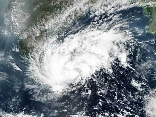
New Delhi: Less than a week after Cyclone Nivar battered Tamil Nadu, another storm is expected to affect the southern state, the India Meteorological Department (IMD) said on Monday. The cyclone will cross the Sri Lanka coast on December 2 and will bring heavy rain over Tamil Nadu and Kerala, it said.
Last week, "very severe cyclonic storm" Nivar had hit Tamil Nadu. While there were no reports of loss of life, about 2.5 lakh people were housed in cyclone shelters in the state as part of safety measures.
The IMD has issued a red-colour coded warning for the southern areas of Tamil Nadu Kerala in view of the brewing storm and said that these areas are expected to receive heavy to very heavy rainfall.
As the sea is expected to become rough due to the weather system, fishermen are advised not to venture into the southeast and adjoining southwest Bay of Bengal from the night of December 1 and along and off east Sri Lanka coast, Comorin area, Gulf of Mannar and Tamil Nadu-Kerala coasts from forenoon of December 2 for the subsequent 24 hours.
Also, those who are out at sea are advised to return to the coast by November 30, it said.

According to the India Meteorological Department, a well-marked low pressure area in the Bay of Bengal intensified into a depression.
"It is very likely to intensify further into a deep depression during the next 24 hours. It is also likely to intensify further into a cyclonic storm. It is very likely to move west-northwestwards and cross the Sri Lanka coast around the evening of December 2," the IMD said.
"It is very likely to move nearly westwards thereafter and emerge into the Comorin area on December 3 morning,” the Cyclone Warning Division of the IMD said.
The IMD said squally weather with wind speed would gradually increase becoming 55-65 kilometres per hour gusting to 75 kmph over southeast and adjoining southwest Bay of Bengal from the night of December 1 and 70-80 kmph gusting to 90 kmph over southwest Bay of Bengal, along and off Sri Lanka coast.
Winds with a speed of 45-55 kmph gusting to 65 kmph are likely over the Comorin area, Gulf of Mannar and Tamil Nadu-Kerala coasts from December 2 forenoon for subsequent 24 hours.
Last week, "very severe cyclonic storm" Nivar had hit Tamil Nadu. While there were no reports of loss of life, about 2.5 lakh people were housed in cyclone shelters in the state as part of safety measures.
The IMD has issued a red-colour coded warning for the southern areas of Tamil Nadu Kerala in view of the brewing storm and said that these areas are expected to receive heavy to very heavy rainfall.
As the sea is expected to become rough due to the weather system, fishermen are advised not to venture into the southeast and adjoining southwest Bay of Bengal from the night of December 1 and along and off east Sri Lanka coast, Comorin area, Gulf of Mannar and Tamil Nadu-Kerala coasts from forenoon of December 2 for the subsequent 24 hours.
Also, those who are out at sea are advised to return to the coast by November 30, it said.
According to a report by ANI, the India Meteorological Department (IMD) has issued a pre-Cyclone watch for South Tamil Nadu and South Kerala coasts predicting that weather conditions there could intensify into a Cyclonic Storm in coming hours.


ADVERTISEMENT
According to the India Meteorological Department, a well-marked low pressure area in the Bay of Bengal intensified into a depression.
"It is very likely to intensify further into a deep depression during the next 24 hours. It is also likely to intensify further into a cyclonic storm. It is very likely to move west-northwestwards and cross the Sri Lanka coast around the evening of December 2," the IMD said.
"It is very likely to move nearly westwards thereafter and emerge into the Comorin area on December 3 morning,” the Cyclone Warning Division of the IMD said.
The IMD said squally weather with wind speed would gradually increase becoming 55-65 kilometres per hour gusting to 75 kmph over southeast and adjoining southwest Bay of Bengal from the night of December 1 and 70-80 kmph gusting to 90 kmph over southwest Bay of Bengal, along and off Sri Lanka coast.
ADVERTISEMENT
Winds with a speed of 45-55 kmph gusting to 65 kmph are likely over the Comorin area, Gulf of Mannar and Tamil Nadu-Kerala coasts from December 2 forenoon for subsequent 24 hours.
Download
The Economic Times Business News App for the Latest News in Business, Sensex, Stock Market Updates & More.
The Economic Times Business News App for the Latest News in Business, Sensex, Stock Market Updates & More.
Download
The Economic Times News App for Quarterly Results, Latest News in ITR, Business, Share Market, Live Sensex News & More.
The Economic Times News App for Quarterly Results, Latest News in ITR, Business, Share Market, Live Sensex News & More.
Related Articles
 Central team surveys damage by cyclone Nivar, rains in Puducherry
ADVERTISEMENT

